Common Raven Monitoring and Management within Desert Tortoise Conservation Areas/ California CORA Monitoring and Management Areas 2022 Request for Proposals
Full Proposal Due: Tuesday, February 1, 2022 (5:00 p.m. PT)
U.S. Fish & Wildlife Service (USFWS) Contact for Technical Questions: Kerry L. Holcomb, Senior Endangered Species Biologist, Email: kerry_holcomb@fws.gov, Office 442‐222‐4300
Bureau of Land Management (BLM) Contact for Technical Questions: Mark Massar, District Wildlife Biologist, Email: mmassar@blm.gov, Office 760‐898‐5367
Superior‐Cronese Critical Habitat Unit (CHU) within Fort Irwin National Training Center Contact for Technical Questions: David H. Davis, Certified Wildlife Biologist-Directorate of Public Works, Email: david.h.davis44.civ@mail.mil, Office 760-380-6435
Fremont‐Kramer CHU within Edwards Air Force Base Contact for Technical Questions: Wes King, Biological Scientist, Email: wesley.king.2@us.af.mil, Office 661‐277‐6298
Ord‐Rodman CHU within Barstow Marine Corps Logistics Base Contact for Technical Questions: Benjamin Cody Leslie, Environmental Protection Specialist, Email: benjamin.leslie@usmc.mil, Office 760‐577‐6744
Joshua Tree National Park Contact for Technical Questions: Michael Vamstad, Wildlife Ecologist, Email: michael_vamstad@nps.gov, Office 760‐367‐5562
Mojave National Preserve Contact for Technical Questions: Neal Darby, Wildlife Biologist Lead, Email: neal_darby@nps.gov, Office 760‐252‐6146
National Fish and Wildlife Foundation (NFWF) Contact for Administrative Questions:
Primary: Eliza Braendel, Senior Manager, Impact‐Directed Environmental Accounts, National Fish and Wildlife Foundation, Email Eliza.Braendel@nfwf.org, Office 415‐593‐7628
Alternate NFWF Contact for Administrative Questions:
Anne Butterfield, Senior Manager, Impact‐Directed Environmental Accounts, National Fish and Wildlife Foundation, Email Anne.Butterfield@nfwf.org, Office 415‐243‐3106
*Proposals will be disqualified, and not reviewed, if they are either incomplete or not in accordance with the specifications detailed below. PROPOSALS NEED TO BE SUBMITTED FOR EACH STRATUM SEPARATELY AND CANNOT BE COMBINED. If anything in the proposal is optional, it must be specifically noted as an option, with a separate budget; otherwise if the proposal is selected, all actions detailed in the proposal will be required to fully satisfy the funding agreement. If the proposal references this RFP, the RFP needs to be included as an Appendix and a reference to that Appendix must be added wherever the RFP is mentioned.
Introduction
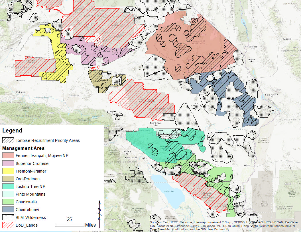
This marks the 10th year of efforts to monitor and manage Common Raven (Corvus Corax; hereafter raven or CORA) depredation on Mojave desert tortoise (Gopherus agassizii; hereafter tortoise) populations within California’s Warm Deserts Ecoregion (Level II, Omernik and Griffith 2014). Management efforts are enacted pursuant to the Raven Predation Control Environmental Assessment (USFWS, 2008). Depredation control efforts have and will continue to be implemented in the high‐quality, sensitive tortoise habitat of southern California (i.e., within designated tortoise critical habitat units as well as other areas of importance as identified by the Raven Sub-group and Renewable Energy Action Team; hereafter CORA Monitoring & Management Area, Map 1). Starting in 2022, monitoring and management actions could be prioritized within Tortoise Recruitment Priority Areas, which are 10 km2 hexagons that contain >0.3 live tortoise observations per transect walked between 2001 and 2019 and buffered by 1.8 km (Holcomb et al. 2021, USFWS unpublished data, Map 1; hereafter Tortoise Recruitment Priority Areas or TRPA).
Work during 2022 will focus on locating active raven nests, determining raven nest stage, and carefully timing the application of food grade oil (i.e., addle) to a target number of raven eggs in each CORA Monitoring and Management Area (Table 1). The goal this year is to addle or recommend to Animal and Plant Health Inspection Service Wildlife Services (WS) all nests within Tortoise Recruitment Priority Areas (TRPAs). We will also conduct 50 point counts in each CORA Monitoring and Management Area to refine our estimates of raven density, to document any detectable annual variation in raven density, and to monitor our progress towards our goal of restoring raven and raven nest density back to levels compatible with Mojave desert tortoise recovery. Finally, we will conduct tortoise decoy survival trials, using three-dimensionally printed tortoise decoys in the Chuckwalla, Fremont-Kramer and Fenner-Ivanpah-Mojave National Preserve areas, to refine our model of depredation as a function of raven density.
Locating active raven nests, determining raven nest stage, and carefully timing the application of food grade oil (i.e., addle) to a target number of raven eggs must be done as efficiently as possible, in terms of cost per unit effort—i.e., cost per egg oiled. Frugality is necessitated here by our limited budget and the likely need to continue this program in perpetuity. As such, nest stage (aka, phenology) will only be monitored to the extent necessary to plan oiling efforts. As such, all planning efforts should consider nest phenology data collected during previous seasons which indicate a mean oiling date of May 1, 2020, with a standard deviation equal to 19.49 days. This predicts that 95% of raven nests in our CORA Monitoring and Management Areas are available to be oiled between the last seven days of March and the first seven days of June, according to 2020 oiling records.
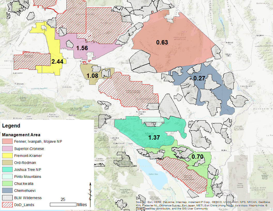
Table 1 2022 CORA Management Monitoring and Management Area specific “Eggs to be oiled” targets, which are the quotient of “2022 Egg Take Targets” divided by the average addling efficiency (93.16%, n=224). Please note that on average, each raven nest contains 4 eggs, but egg counts vary with fall precipitation, spring warming rate, and proximity to subsidies (Hanley et al. 2021a&b). *indicates that a management area will not receive treatment through this program during Calendar Year 2022.
| 2022 Management Areas (abbreviation) | Mean 2020 Density | Eggs Oiled in 2020 | 2022 Egg Take Target | Eggs to be Oiled in 2022 |
| Chemehuevi (CI)* | 0.27 | 31 | 0 | 0 |
| Fenner, Ivanpah, MNP (FIM) | 0.63 | 149 | 228 | 237 |
| Fremont-Kramer (FK) | 2.44 | 961 | 944 | 982 |
| Ord-Rodman (OR) | 1.08 | 281 | 48 | 50 |
| Superior-Cronese (SC) | 1.56 | 393 | 532 | 553 |
| JTNP, Pinto Mountains (JP) | 1.37 | 105 | 127 | 132 |
| Chuckwalla (CW) | 0.7 | n/a | 193 | 201 |
| Totals | 1920 | 2,072 | 2,155 |
Map 1 California CORA Monitoring and Management Areas. Each area is color-coded so that the management area name can be found in the legend. Chemehuevi is included in this map but will not receive treatment through this program during Calendar Year 2022.
Map 2 Estimated mean CORA density (ravens/km^2) within each California Management Areas. Management Areas labeled according to mean 2020 point count estimates of raven density (ravens/km2,; 513 observations at 534 two-kilometer distance points plots). Chemehuevi is included in this map but will not receive treatment through this program during Calendar Year 2022.
1) Performance Period and Total Survey Effort per Priority Area
Nest surveys and oiling will be performed over an approximately two-month period, between March 24 and June 9, 2022 in each CORA Monitoring and Management Area (Map 1, please see Figure 1 for further details regarding area-by-area “Eggs to be Oiled in 2022” targets). Additionally, each crew should include three weeks for data curation, image analysis, report writing, and editing based on comments received for each management strata, resulting in a performance period that will not exceed June 30, 2022.
For each management area, total effort required to locate and oil the target number of eggs will be clearly detailed in the proposal by person days and estimated cost per raven egg oiled (partial nests will be oiled and nests will not be monitored for phenology or offending status outside of an initial sweep to calibrate that year’s nest phenology). This person day estimate should also include the deployment and retrieval of 22 tortoise decoy bait stations at predetermined random points in the Fremont-Kramer, Chuckwalla, and Fenner-Ivanpah-Mojave National Preserve areas, and conduct fifty ten-minute two-kilometer radius point counts (between sunrise and 1400h, with sustained winds of <40km/h, and no more than light precipitation).
Project administration and fieldwork efforts will be separated and described clearly by total person days for each category. Project administration and fieldwork person days will be further broken down by specific tasks such as, but not limited to, database management, bait station image review and analysis, initial nest monitoring, oiling effort, and point count effort.
2) Budget
The Budget should be organized into cost type categories. Budget Categories should be further itemized into distinct line items. Budget descriptions need to be estimated clearly and itemized by tasks such as, but not limited to: raven egg oiling, point counts, database management, deployment and retrieval of 22 tortoise decoy bait stations at predetermined random points in the Fremont-Kramer, Chuckwalla, and Fenner-Ivanpah-Mojave National Preserve areas, project administration, tortoise decoy bait station photographic data review, hotel rate (cost per day and number of days, these should be kept to a minimum), camp rate (cost per day and number of days), mileage (cost per mile by number of estimated miles), equipment/supplies (total cost, including the purchase of 176 non-rechargeable batteries for camera traps), and overhead (percent of labor).
Monthly financial reports will be accepted in either one of two formats. The first option that will be accepted is an estimated daily cost per person day with the total person days for that month as well as an estimate of cost per egg oiled. The first option must include an attached memo each month with a detailed description of how the person day cost was estimated from expenses and tasks. The memo can be reused each month. The second option that will be accepted is an estimated cost for each task that month such as, but not limited to, fieldwork (days multiplied by a fixed rate per day), accommodation rates (cost per day), mileage (cost per mile by number of miles), equipment/supplies (total cost), project administration (days multiplied by a fixed rate per day), and overhead (percent of labor).
3) Nest Location and Egg Oiling
Nest searching and egg oiling will be conducted during daylight hours by slowly driving established open routes and by walking to monitoring points or known nest points (Maps 3 through 8), while scanning suitable raven nesting substrates with and without binoculars. Nests can also be located by watching raven behavior from a vantage point that enables the use of either a rangefinder or compass to map possible nests across a Joshua-tree forest within identified priority areas. Reaching addling targets may require more intensive searching in hard-to-reach locations during some breeding seasons as a result of environmental conditions depressing raven reproductive output. In a safe manner, searches and addling will be conducted by one to two personnel (preference determined by personnel) in a vehicle with individual(s) observing, navigating, preparing to addle, and driving.
Speeds on dirt roads will not exceed 20 miles per hour. On paved roads, a balance will be made between safety and nest search effectiveness but posted speed limits will not be exceeded.
Upon sighting a potential raven nest, the vehicle or pedestrian will stop. The crew member(s) will then take a closer look at the birds/nest in question with a high power spotting scope. In cases of a raven nest or highly suspected raven nest, surveyors will then use a pole mounted camera-sprayer to determine whether or not eggs are present in the nest. If eggs are present, oil should be applied. Then basic nest data will be collected on the provided datasheets and according to the provided data dictionary—note that this project’s data formats are specific to our analysis process and data not conforming to these supplied data dictionaries will not be accepted (e.g., see Attachment Six).
The vehicle or pedestrian survey will re‐commence when the observer’s full attention is again on the landscape.
4) Identification of Desert Tortoise Remains
Any observed tortoise remains will be catalogued and photographed on a white background with a standard scale to clearly show the composition of identified remains. Record details on the provided datasheets and according to the provided data dictionary (e.g., number of individuals present and length(s) of carapace; see Attachment Three). Time since death will be based upon a standardized key from Berry and Woodman 1984 (modified in 2000; Attachment Two). Desert tortoise remains will be removed from the sample plot, labeled in separate bags after being dried, and mailed to USFWS contact at end of season.
5) Notification of Desert Tortoise Remains
In the event that desert tortoise remains are positively identified at a nest or perch sites, surveyors will notify USFWS and either the BLM, National Park Service (NPS), or military installation (depending on land ownership) point of contact immediately by electronic mail, if possible, or if internet coverage is limited, no later than 72 hours after the observation. Surveyors will follow Attachment Three guidelines and provide USFWS with Critical Habitat Unit (CHU), nest ID, substrate, GPS site location (NAD 1983 Zone 11, Easting and Northing in meters), species occupying nest, breeding development stage, number of carcasses, description of remains, age class, time since death, and date remains were found. The identified USFWS contact will notify WS, and WS will coordinate with appropriate recipients to facilitate removal of offending ravens.
Immediately notify USFWS and either the landowner contact if any desert tortoises are found hit or dead along any of the survey routes. Include the location of remains (UTM coordinates), time since death, age class of tortoise, and any other pertinent information. This information is being used to further the efficiency of USFWS’s and BLM’s efforts to manage road mortality across the range of the tortoise.
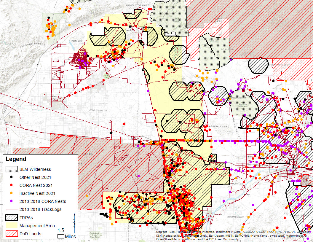
Map 3 Common Raven (CORA) as well as other large nests located within the Fremont-Kramer CORA Monitoring and Management Area. In addition to Tortoise Recruitment Priority Areas (TRPA), track-logs from previous years, and Department of Defense Lands.
Map 4 Common Raven (CORA) & other large nests located within the Joshua Tree NP and Pinto Basin CORA Monitoring and Management Area. In addition to Tortoise Recruitment Priority Areas (TRPAs) and track-log from previous years.
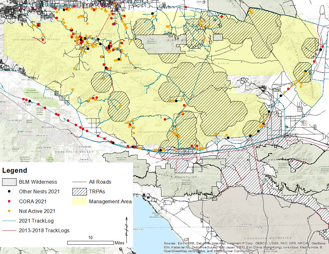
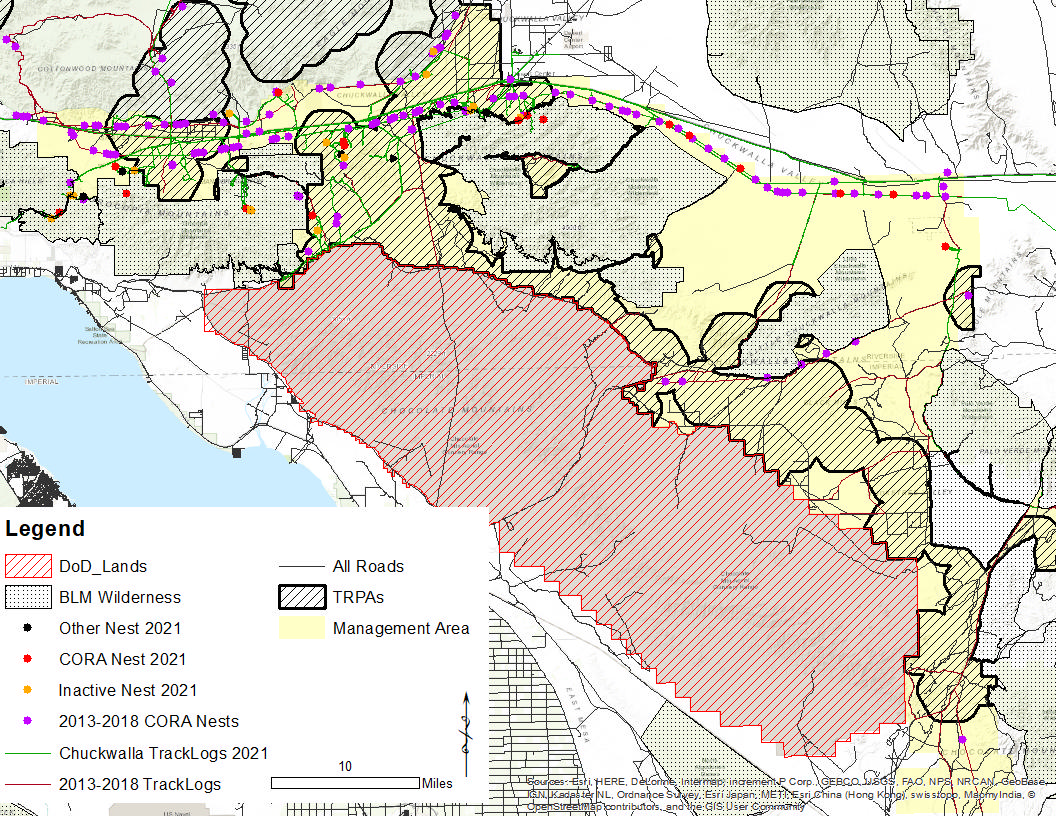
Map 5 Common Raven (CORA) as well as other large nests located within the Chuckwalla Monitoring and Management Area. In addition to Tortoise Recruitment Priority Areas (TRPA), track-logs from previous years, and Department of Defense Lands.
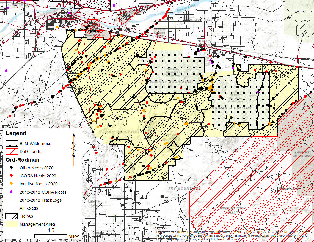
Map 6 Common Raven (CORA) as well as other large nests located within the Ord-Rodman Monitoring and Management Area. In addition to Tortoise Recruitment Priority Areas (TRPA), track-logs from previous years, and Department of Defense Lands.
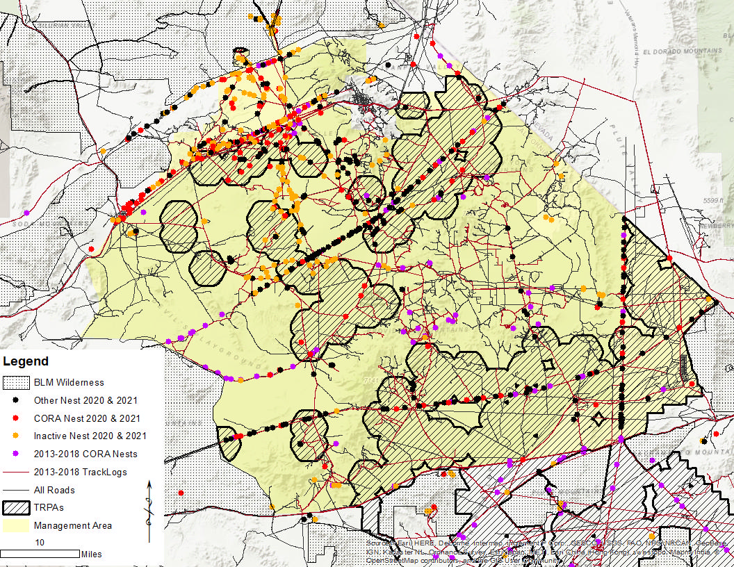
Map 7 Common Raven (CORA) as well as other large nests located within the Superior-Cronese Monitoring and Management Area. In addition to Tortoise Recruitment Priority Areas (TRPA), track-logs from previous years, and Department of Defense Lands.
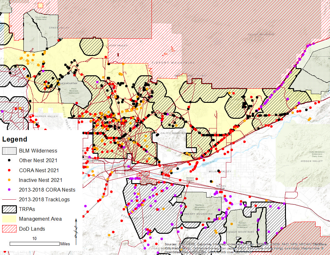
Map 8 Common Raven (CORA) as well as other large nests located within the Fenner-Ivanpah-Mojave National Preserve Monitoring and Management Area. In addition to Tortoise Recruitment Priority Areas (TRPA), track-logs from previous years, and Department of Defense Lands.
6) Measuring Common Raven Predator Pressure with Tortoise Decoys paired with Passive Infrared Camera Traps
The recipient will deploy and retrieve 20 tortoise decoy stations, one camera-only station (camera control), and one novel-object station (object control) at 22 predetermined random points in ONLY the Fremont-Kramer, Chuckwalla, and Fenner-Ivanpah-Mojave National Preserve management areas. The recipient will review images from each bait station and report raven observations within a one-and-a-half-meter hemispherical area centered on the tortoise decoy. Models will be deployed opportunistically during initial nest searching and oiling phase, but before April 10, 2022. Care should be taken to deploy these models when ravens are not visibly present in the area. Models will be left in place for 15 days and no more than 20 days.
7) Deliverables
The recipient will provide the following deliverables (all GPS locations will be in UTM NAD83 datum). All electronic files will be compatible with Adobe Acrobat or Microsoft Office (i.e., Word, Excel), and all electronic data will be compatible with ESRI ArcMap version 10 (e.g., shapefile or geodatabase). Data files will also be mailed via FedEx or USPS to the USFWS contact identified in the funding agreement.
- Monthly:
- Number of eggs oiled
- Number of nests with a potential for oiling
- GPS track logs (as ArcGIS shapefile) of all routes driven within the study areas
- GPS locations of all desert tortoise remains that cannot be associated with a specific raven nest or perch
- GPS locations of all desert tortoise sightings (include roadkill)
- See bullet point #2 “Budget” for Monthly Financial Requirements
- At the end of the funding agreement:
- A summary Excel spreadsheet that contains (see Attachment Five):
- Nest ID
- Nesting substrate
- Locations in UTMs (Easting, Northing)
- Breeding status of occupied nest
- Description of desert tortoise remains associated with nest or nearby perch site
- Estimated time since death for the tortoise remains
- Date found
- Most recent date of observation
- Location and number of raven food pellets positive for tortoise remains (optional)
- Notification of desert tortoise remains, if applicable
- Results of WS actions (optional)
- NFWF Final Programmatic Report (A draft will be provided with at least one week for review at least one week before June 30, 2022).
- Executive summary
- Methodology
- Results
- Nest locations in UTMs
- Dollars per egg oiled
- Separate maps of:
- CHU boundary with land ownerships, survey routes, and powerlines
- Nest sites (include key indicating active nests, inactive nests, and bird species) and incidental live desert tortoise encounters and carcass locations (include raven predated and roadkill tortoises)
- Summary tables detailing:
- Desert tortoise carcasses by age class (i.e., adult, sub‐adult, juvenile, and hatchling)
- Oil application actions at Common Raven nest sites and effect on nest success and fledging (optional)
- QA/QC process and assurances for data and reports
- Discussion
- Compare results to 2021 egg addling efforts for the respective strata
- Summary page of recommendations for future raven monitoring and management actions (Optional)
- All photographs and recorded details of desert tortoise remains encountered; photographs need to be GPS tagged
- All photographs and recorded details of live desert tortoise observations; photographs need to be GPS tagged
- All photographs and recorded data of nests; photographs need to be GPS tagged
- Scanned field datasheets as pdf’s
- ArcGIS shapefile or geodatabase (i.e., shapefile, GPS track-log files) needs to be mailed electronically and physically on a flash drive to USFWS contact
- NFWF Final Financial Report
- A summary Excel spreadsheet that contains (see Attachment Five):
8) References
Hanley, B., Currylow, A., Holcomb, K. L., Shields, T., Boland, S., Boarman, W., and Vaughn, M. StallPOPdV4 Web Interactive: Software to compute population control treatments of a subsidized predator [Online Software: https://cwhl.vet.cornell.edu/tools/stallpopd#collapse5]. 2021a. doi: https://doi.org/10.7298/sk2e-0c38.4. 2021a
Hanley, B., Currylow, A., Holcomb, K. L., Shields, T., Boland, S., Boarman, W., and Vaughn, M. Identifying population management strategies for avian predators: a decision tool. Human-Wildlife Interactions. 2021b.
Holcomb, K. L., Coates, P. S., Prochazka, B. G., Shields, T., and Boarman, W. I. A desert tortoise-common raven viable conflict threshold. Human-Wildlife Interactions. 2021.
Omernik, J.M. and Griffith, G.E., 2014. Ecoregions of the conterminous United States: evolution of a hierarchical spatial framework. Environmental management, 54(6), pp.1249-1266.
USFWS, 2008. Environmental Assessment to Implement a Desert Tortoise Recovery Plan Task: Reduce Common Raven Predation on the Desert Tortoise. US DOI, Ventura, California. Available at: www.fws.gov/carlsbad/PalmSprings/DesertTortoise/Raven%20EA%20Final%203-…;
Note: Please review the RFP PDF for the complete RFP including attachments.